

 How to use B4UFLY app. Fly your drone in the United States
B4UFLY (App Store)
is an application that allows you to check on the map the no-fly zone of drones in the United States.
If you plan to fly drones in the United States, install them in advance.
In the United States and other countries, there are differences in the rules depending on whether takeoff weight is 250g or more. However, the only difference between a drone weighing less than 250g and a heavier drone in the United States is aircraft registration requirement. Please note that other flight rules apply to drones of all weights.
Please refer to the Drone flight rule page for drone flight rules in each country, including the United States.
Termination of B4UFLY service: B4UFLY alternative app
The B4UFLY app ended its service on February 1, 2024. In exchange, the FAA has approved the following four private companies to provide B4UFLY services to recreational drone pilots. Additionally, each company provides free web services that allow you to use B4UFLY without installing an app. Users in regions outside the US where the app is not available should use this service.-
AirHub Portal

Airspace Link Inc Business free
AirHub® Portal is a streamlined application designed for all drone pilots, offering sophisticated pre-flight risk assessment, improved situational awareness, B4UFLY services, and the capability to request LAANC (Low Altitude Authorization and Notification Capability) approval directly from the FAA with just a few clicks in a single application.
view the details(App Store)Airspace Link Inc Official siteAirspace Link B4UFLY Web service -
AutoPylot For Drones
AutoPylot, INC Productivity free
AutoPylot is a free, FAA-approved supplier of B4UFLY and LAANC, making it the easiest way for drone pilots to check airspace, create missions, and get drone insurance.
view the details(App Store)AutoPylot, INC Official site -
Avision for Drones
Avision Inc. Business free
Integrated solution for drone operations: FAA LAANC and B4UFLY service, flight planning, video streaming. Avision UTM supports first responders and advanced air mobility.
view the details(App Store)Avision Inc. Official siteAvision B4UFLY Web service -
UASidekick
UASidekick Inc Reference free(Offers In-App Purchases)
UASidekick is a subscription based airspace awareness tool that ensures safety in the NAS for both manned and unmanned pilots alike. The app allows remote pilots to easily file flight plans that integrate seamlessly with FAA Flight Service and the FAA LAANC system.
view the details(App Store)UASidekick Inc Official siteUASidekick B4UFLY Web service
Install B4UFLY app
-
B4UFLY
Federal Aviation Administration utility free
It is an application for UAV (unmanned aerial vehicles) pilots provided by the United States Federal Aviation Administration (FAA). UAV no-fly zones in the United States can be seen on a map. You can specify the location and time in advance and check if the flight is prohibited.
view the details(App Store)
How to use B4UFLY app
 B4UFLY is easy to use.
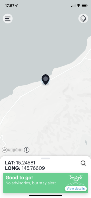
If you enable the location information of the iPhone and start the B4UFLY app, you can check whether you can fly the drone at the current location.
If “Good to go!” Is displayed in green at the bottom of the screen like this, it is the recommended flight area.
B4UFLY is easy to use.
If you enable the location information of the iPhone and start the B4UFLY app, you can check whether you can fly the drone at the current location.
If “Good to go!” Is displayed in green at the bottom of the screen like this, it is the recommended flight area.
Attention If you specify a location other than US territory in the B4UFLY app, the correct judgment result will not be displayed. For example, if you specify an airport in Japan where drone flight is prohibited, "Good to go!" Will be displayed. Use this only for judgments within U.S. territories.
 When you tap the
By tapping the
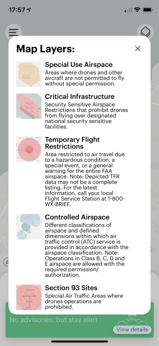
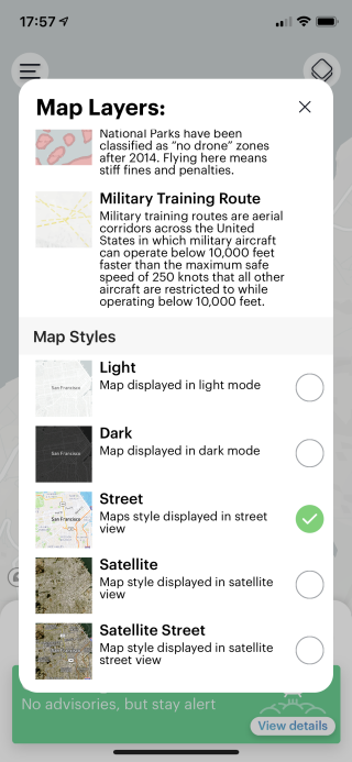 When you scroll the explanation screen, you will see this.
The display method of the map can be selected from "Light", "Dark", "Street", "Satellite", and "Satellite Street".
Please switch to your preference.
When you scroll the explanation screen, you will see this.
The display method of the map can be selected from "Light", "Dark", "Street", "Satellite", and "Satellite Street".
Please switch to your preference.
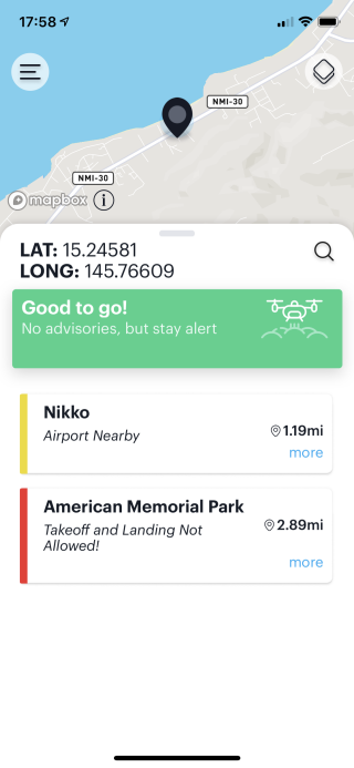 If you tap the part such as "Good to go!" At the bottom of the screen, you will see this screen.
Advice on the flight at that point and nearby caution / no-fly zones are listed.
If you tap the part such as "Good to go!" At the bottom of the screen, you will see this screen.
Advice on the flight at that point and nearby caution / no-fly zones are listed.
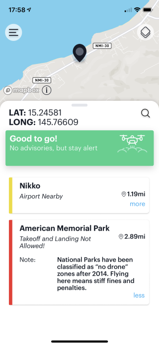 Tap an item in the list to read its detailed information.
You can read the reasons for the flight ban.
Tap an item in the list to read its detailed information.
You can read the reasons for the flight ban.
 By tapping anywhere on the map, you can read flight tips and other information about the tapped location.
Before actually going to the place, you can check if it is a no-fly zone.
By tapping anywhere on the map, you can read flight tips and other information about the tapped location.
Before actually going to the place, you can check if it is a no-fly zone.
Use B4UFLY from your browser
